
Land measurement apps allow anyone, whether professional or amateur, to quickly obtain reliable area and distance data. Previously, measuring was a time-consuming and error-prone process, relying on tape measures, measuring tapes and other impractical hand-held instruments. Today, all you need is a smartphone to collect accurate information in real time.
Having these tools is particularly useful for those who work in fields such as surveying, civil construction, interior design and even home renovations. They can be used to delimit spaces, check room measurements or even calculate the size of a plot of land before starting a project. Check out some of these apps.
1. Area and Distance Meter
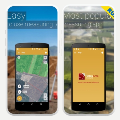
The Area and Distance Meter is one of the most popular options for Android, based on Google Maps. With it, you can locate the desired terrain and, by drawing a polygon directly on the map, obtain the resulting area in square meters. The application also allows you to calculate distances between selected points, and it is easy to share links with the obtained measurements.
Another difference is that most of the functions are available for free, although there is the possibility of purchasing a paid version without ads and with extra features. This way, anyone, whether a farmer wanting to delimit their fields or a real estate agent evaluating urban lots, can benefit from a fast, intuitive and well-structured app in terms of cartographic precision. Available for Android.
2. Magicplan
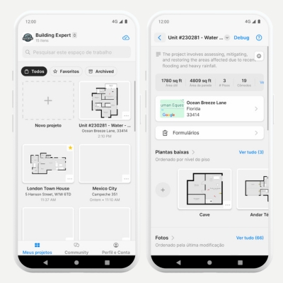
Magicplan stands out for integrating the smartphone camera into the measurement process, enabling the creation of floor plans without the need to move furniture or make major changes to the space. After calculating distances between walls and other items, the app generates visual diagrams that can be saved in formats such as PDF, JPG or PNG. Architecture and design professionals will find a tool here that speeds up inspections and plans new layouts.
Another advantage is the ability to directly publish results on social networks or websites, making collaboration with clients and colleagues more fluid. However, some features remain restricted in the free version, such as the use of certain objects and libraries. Available for Android.
3. Bubble level, Plumb line, Ruler
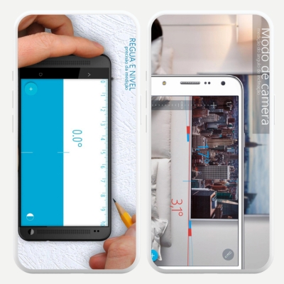
The Bubble Level, Plumb, Ruler app combines three functionalities in a single platform: a conventional ruler, a bubble level and an angle meter. With its digital ruler, you can work in four main modes: point, line, plane and level, obtaining data that is very faithful to reality. This is especially useful for small renovation jobs or checking measurements on flat surfaces.
The bubble level and angle meter help determine the horizontality or verticality of a surface, as well as assess the inclination of corners and edges. To refine the measurement, there is an audible alert that indicates when the device detects perfect alignment. Available for Android.
4. AutoCAD
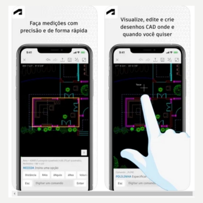
AutoCAD is a well-known name among architects, engineers and designers, having been present in the technical drawing software market for decades. The mobile version, although simpler than the desktop version, provides essential features for viewing and editing previously created projects.
The practicality of carrying your drawings and plans in your pocket, combined with the precision of the measuring tools, makes it a fundamental ally in surveying, planning and project execution work. Available for Android.
5. Laser Level and Inclinometer
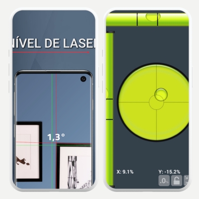
Laser Level and Inclinometer focuses on sensors such as a gyroscope and accelerometer, transforming your phone into a multipurpose tool. It accurately displays data on vertical and horizontal levels, as well as offering the option of a complete bubble level, bringing greater reliability to those who need to take quick and specific measurements.
Although it produces more accurate results when the device has a laser camera, this functionality is not mandatory. Even on regular smartphones, the app works to calculate slopes, inclines and alignments without requiring the user to be connected to the internet. Available for Android.
Benefits of land measurement apps
- Time saving: these applications eliminate some of the manual work and do away with equipment such as tape measures or theodolites, speeding up data collection.
- Access to real-time results: by using the GPS functions or cell phone sensors, it is possible to reach accurate conclusions immediately, speeding up inspection or purchasing processes.
- Multiple export formats: Applications that convert measurements to PDF, JPG or PNG make it easier to exchange information with customers, suppliers or coworkers.
- Collaborative tools: Through shareable links or cloud storage, teams can discuss and review projects without being physically on-site.
- Artificial Intelligence Resources: some applications use algorithms that minimize calculation errors, increasing the reliability of results and reducing rework.
How to choose applications to measure land?
When choosing a measuring app to download, consider the complexity of your project. If you just need to measure the area of a plot of land or check some alignments, apps focused on specific calculations may be enough. However, if the work involves creating detailed floor plans or making corrections to ongoing projects, opt for more robust solutions, such as AutoCAD.
Also, consider the features that are offered for free versus those that are locked behind paywalls. Some apps may work perfectly in the basic version, while others require a subscription to unlock important features. Reading user reviews and checking the developer’s update policy can help you understand the quality of long-term support.
It is also important to check the compatibility with your mobile device. Some apps require special settings or advanced sensors, such as gyroscopes and lasers integrated into the cameras. If your device is simpler, you may not be able to use all the features, and you will need to look for alternatives that offer good performance even with limited hardware.
Frequently Asked Questions about Land Measurement Apps
1. Do these apps replace traditional measurements by engineers and surveyors?
In many cases, they can provide data close to professional methods, but it is still advisable to rely on a specialist when it comes to complex projects, such as large construction works and geotechnical studies. The application is suitable for preliminary surveys, but official measurements may require certificates and technical reports that only specific equipment can provide.
2. Is measurement via apps subject to signal or weather interference?
Yes, accuracy can drop in locations with very dense cloud cover or physical obstructions (such as tall buildings and mountains) that make it difficult to triangulate satellites. Indoors or underground, the GPS signal also tends to be weak or non-existent. In this context, map-based apps can be more reliable, as they only rely on a good internet connection.
3. Is it possible to share measurements in real time with other team members?
In many applications, yes. Some have cloud-based collaboration features or link generation so that other people can access the data. This speeds up communication and avoids unnecessary travel, as everyone can see and even edit the areas marked on the map.
4. Do measurement apps consume a lot of cell phone battery?
They tend to use GPS intensively, which increases power consumption. Additionally, if they need a constant internet connection to access online maps, the consumption is even higher. It is recommended to bring a power bank or make sure the battery is well charged before starting extensive measurements in the field.
5. Do these tools support multiple units of measurement?
Yes, most allow you to switch between meters, feet, miles and other measurements, adjusting to the user's needs or the standard adopted in each location. This immediate conversion is very useful when dealing with international partners or projects that require specific standardization.
Read also: Applications for measuring environments
Get accurate measurements for your projects
Land measurement apps offer a smart solution for those looking for agility and accuracy in data collection. Whether it’s to check areas, create plans or adjust construction details, these software programs bring practicality to a process that previously required travel and expensive tools.
By combining technology, ease of use and robust features, they become inseparable companions for professionals and enthusiasts, enabling assertive decisions and better-founded projects.